


 142 / 218

[
] 140
E
XTREME WEATHER EVENTS
exert tremendous stress on
societies and economies worldwide. Civilizations have
learnt throughout the years how best to cope with their
specific, average climate. Deviations from climatic means or
average weather conditions can bring loss of life and destruc-
tion of property, in proportion to the severe or extreme
meteorological phenomena that occur. For example, extreme
rainfall (high or low) values can cause flooding or drought,
causing tremendous losses to society, agriculture and energy
production. However, it is also possible that ‘good’ weather and
climate will bring beneficial rainfall, favourable to the suste-
nance of water supplies, hydroelectricity or irrigation.
A recent example is the massive impact of hurricane Katrina
on the New Orleans population. There were immense losses
to local and national economies, as well as significant social
and political ramifications. Another example is the sudden and
swift polar air movements over California and San Antonio,
Texas, in mid January 2007. These caused large losses to citrus
fruit production in California, interruption to power lines in
several areas and the closure of airports due to freezing rain.
In South America, ‘hurricane’ Catarina (so called because it
landed over the State of Santa Catarina, Brazil) brought tremen-
dous loss of life and significant material and architectural
damage. It also raised the concern that Catarina might indi-
cate the first regional impacts of global warming as a result of
forest burning, as well as increased fossil fuel usage in indus-
trial activity and transportation. In addition, areas of southern
Brazil vital to grain production (soybean, wheat, corn, rice)
for export and for internal consumption suffered recurrent
droughts, which brought huge losses to the local and national
economy as well as to the insurance companies.
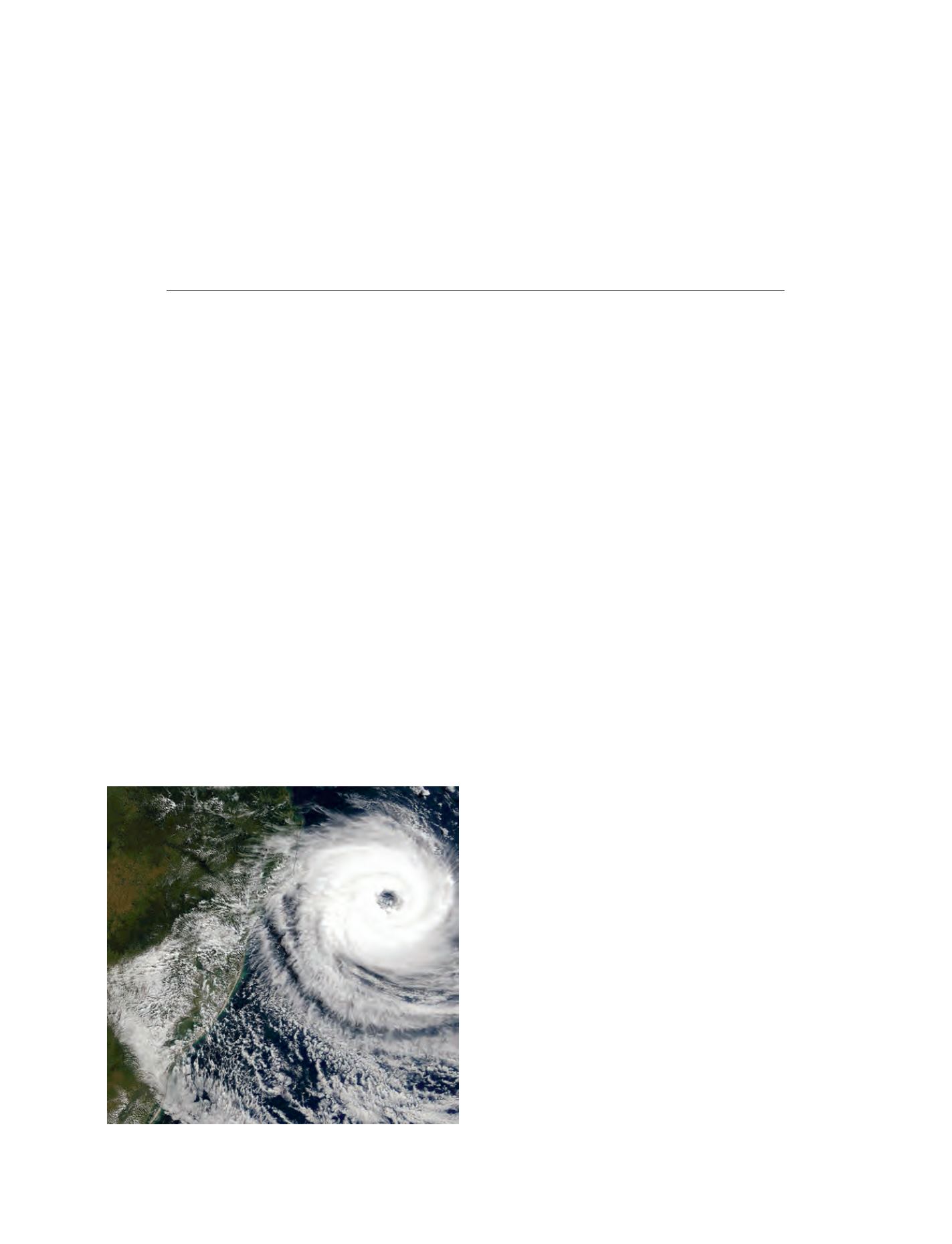
‘Hurricane’ Catarina on the Brazilian coast
Between 27 and 28 March, 2004 a hurricane-like phonome-
non developed in the South Atlantic. This was the first
‘hurricane’ recorded over the South Atlantic basin since the
initiation of geostationary satellite imagery during the mid
1960s. The storm hit the coast of southern Brazil at Santa
Catarina on 28 March. Even though no direct measurement
was made (the nearby radar was non-operational at the time)
the intensity of the winds was estimated by models and satel-
lite imagery to the order of 90 kilometres per hour, with winds
of up to 150 kilometres per hour.
Usually, hurricanes do not form in the southern Atlantic due
to greater wind speeds at high altitude, which prevent storms
from gaining height and strength. Catarina started from a cut-
off low in the mid South Atlantic. In almost all observed cases,
these lows move towards the south-eastern Atlantic and dissi-
pate. Catarina however, moved towards the coast of Brazil and
changed structure and dynamics in a very unusual manner,
building up strength and forming a hurricane-like phenome-
non that became known as ‘hurricane Catarina’. The inaccurate
prediction of Catarina’s intensity, development and impact
generated a high level of media and public criticism of the
meteorological institutions involved.
The need for an integrated regional operational project
In the wake of Catarina, the National Meteorological Services
(NMS) of several countries in southern South America began
discussions and activities aimed at the mitigation of such disas-
ters. Since severe weather phenomena over the region usually
have their genesis in higher latitudes in the south, intensifying
as they move from Argentina to Uruguay to Paraguay and Brazil,
it is obvious that a joint effort is needed for maximum effec-
tiveness.
The region is large and requires improved data (in-situ, satel-
lite and radar derived) on land, and on the south-western South
A virtual centre for disaster reduction in
South America: monitoring, prediction and
early warning of severe weather events
Antonio Divino Moura, Instituto Nacional de Meteorologia, Brazil
Satellite picture, taken on 27 March 2004, of the ‘hurricane’ Catarina
Photo: Jacques Descloitres – NASA/GSFC – MODIS satellite