


 145 / 156

[
] 145
• Third generation regional climate model (HadRM3) derived
projected climate scenarios
• Hydrological modelling using SWAT including irrigation water,
and agricultural crop modelling using EPIC modelling.
The modelling framework used in this study established iden-
tified links between these components. These included
databases and models that were designed to facilitate water
resources and crop modelling under climate variability and
climate change scenarios. The baseline and future climate
scenarios from HadRM3 were used as inputs to both hydrolog-
ical and crop simulation models.
A range of emission scenarios was developed in the
Intergovernmental Panel on Climate Change (IPCC) Special
Report on Emission Scenarios (SRES). These reflected a wide
range of the main demographic, technological and economic
driving forces of future emissions. The future climate was
projected for the years 2071 through 2100 for IPCC SRES A2
and B2 scenarios (A2 and B2 represent high- and low-level emis-
sion scenarios respectively for the region in which India lies).
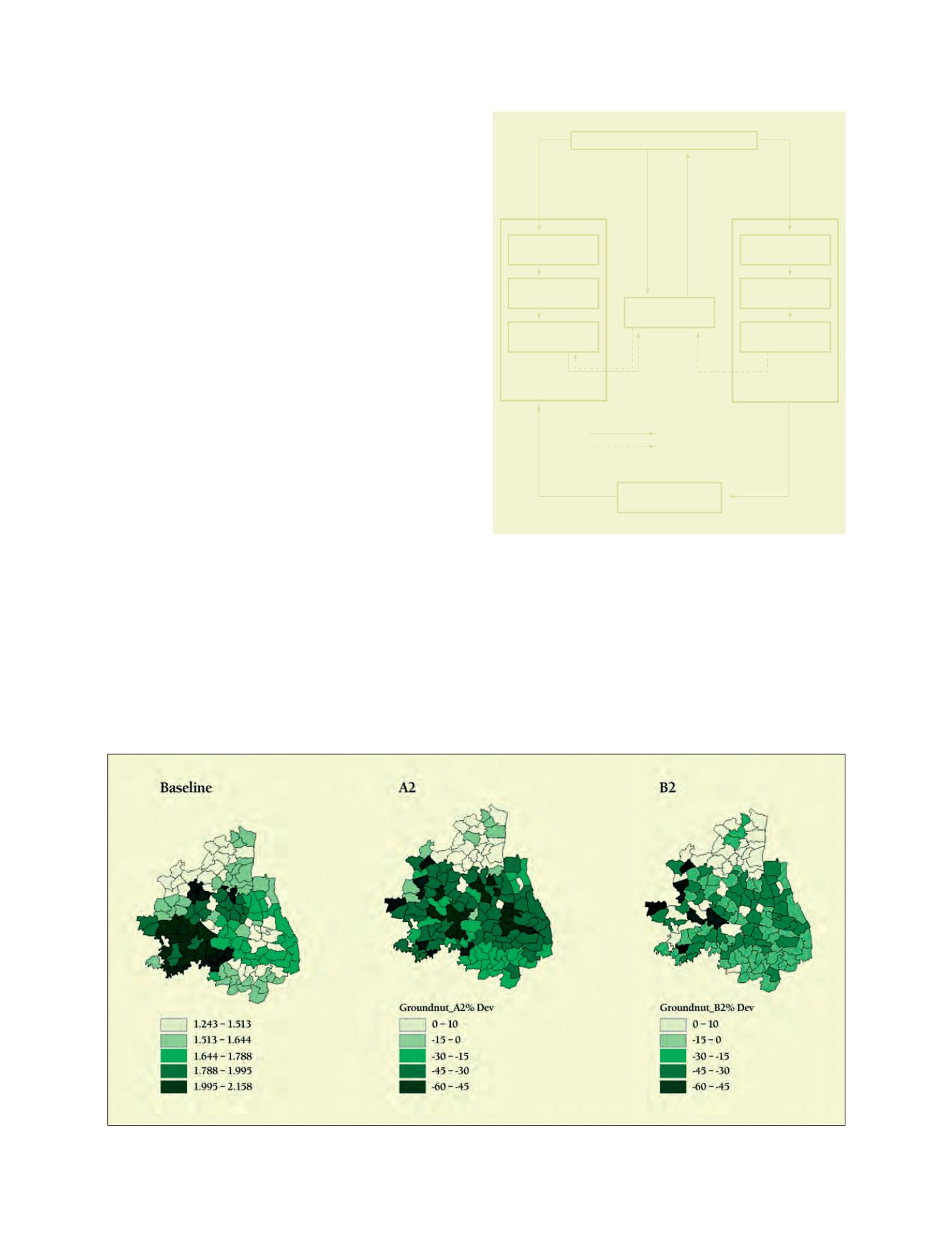
Results for the Pennar region revealed that the mean annual
flows in the river system would increase by 8 per cent in A2 and
4 per cent in B2, whereas the increases in evapotranspiration losses
were found to be about 10 per cent in A2 and 12 per cent in B2.
Three rain-fed crops (groundnut, jowar, sunflower) showed
decreased yields under A2, whereas in B2 they seemed to fare
relatively better. The decrease was significant for groundnut: 38
per cent for A2 and 20 per cent for B2. Rice, being an irrigated
crop, showed a decrease in yield by 15 per cent and 7 per cent
for A2 and B2 scenarios respectively. The decrease in yields was
mainly due to further increases in temperature under climate
change scenarios, as has also been observed in experiments.
The modelling framework developed by RMSI is biophysical
in nature and can adequately predict the observed and current
cropping mix. This framework can be ported to other areas with
or without modifications.
Conclusion
Geospatial technologies are indispensable tools to manage
natural disasters, as evidenced by the case studies above. An
innovative combination of information technologies in general,
and geospatial technologies in particular, with science and engi-
neering, makes the best decision support systems for managing
disasters.
Source: RMSI
Percentage deviation from baseline groundnut yields
Graphical User Interface
INPUT
MODELLING
OUTPUT
EPIC
INPUT
MODELLING
OUTPUT
SWAT
DATABASE
Derived surface water for
irrigated agriculture
Front end procedures
Back end procedures
The system architecture of the IMS
Source: RMSI