


 142 / 156

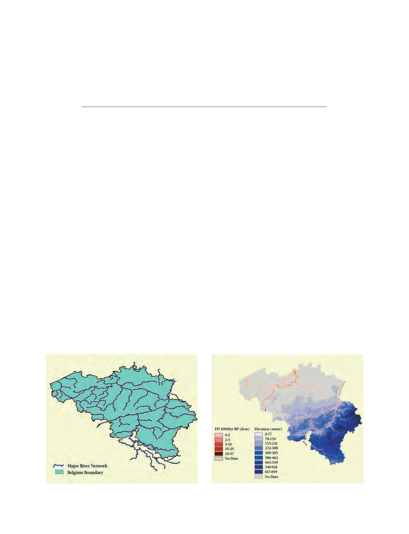
Source: RMSI
Flood depth map for 10,000-year return period overlaid on DEM
[
] 142
I
NFORMATION IS THE
key for managing disasters better. Fortunately,
access to information and its timely analysis for better decision-
making and management is fulfilled today by information
technologies in ways that were not effective, efficient or economical
a decade ago. Geospatial technologies, and geographical informa-
tion systems (GIS) in particular, provide the tools to store spatial and
non-spatial data digitally and a platform to retrieve, analyse and repre-
sent this data in ways that support decision-making. GIS, along with
other geospatial technologies such as global positioning systems
(GPS), remote sensing, aerial photography and web mapping, form
a toolkit that is critical for improved disaster management.
The following case studies demonstrate RMSI’s application of
these geospatial technologies in different phases of the disaster
management cycle:
1
1. Development of a GIS-based flood hazard model to prevent
disasters
2. Vulnerability and adaptation to drought – economic impact
scenarios
3. Addressing vulnerability to climate variability and climate
change through assessment of adoption issues and options.
Case study 1: Development of a GIS-based flood hazard
model to prevent disasters
Flooding is a hazard with serious socio-economic consequences
for all activities and infrastructure within an affected floodplain.
Accurate delineation of the extents and depths of floods within
the floodplain is essential for flood management officials to make
sensible and fair decisions regarding construction, insurance, and
other regulated practices on land and property potentially affected
by flooding. While there are plans for the whole of Europe to
model floods, Belgium was chosen as the first country, due to
business needs. The model development part of the project
entailed extensive spatial analysis, including the development of
a modelled river network, a hydrologically corrected digital eleva-
tion model, catchment delineation, rainfall to runoff modelling,
and flood extent and flood depth information.
The flood risk model developed by RMSI comprised four differ-
ent modules:
Event definition module
– This module involved gathering infor-
mation on historical flows covering all the river gauge stations
across Belgium and the development of flow-frequency curves
using extreme value distribution. The stochastic event set
contained a range of possible winter and summer river flood
events that caused losses on and off the major floodplains, repre-
senting flood events sampled from the equivalent of 10,000 years
of simulation. The event set was based on extensive analysis of
hydrological data and research into the causes of historical events,
and was calibrated against historical records of extreme flows and
precipitation. Flood hazard was determined for each of stochas-
tic events at administrative division boundaries resolution.
GIS and spatial technologies in disaster
management: a case study approach
Satya Priya, General Manager, Spatial Modeling, RMSI
Major rivers of Belgium
Source: RMSI