


 64 / 156

ing in the community.
8
Through this programme flood maps
for the area were developed, a community based flood alert
system was created, and members of the community trained in
rainfall and river flow data collection. The project also
conducted community riverbank erosion training programmes
and trained members of the community in related disaster
management. These activities increased community awareness
and provided tools for the community to be better prepared for
future flood events.
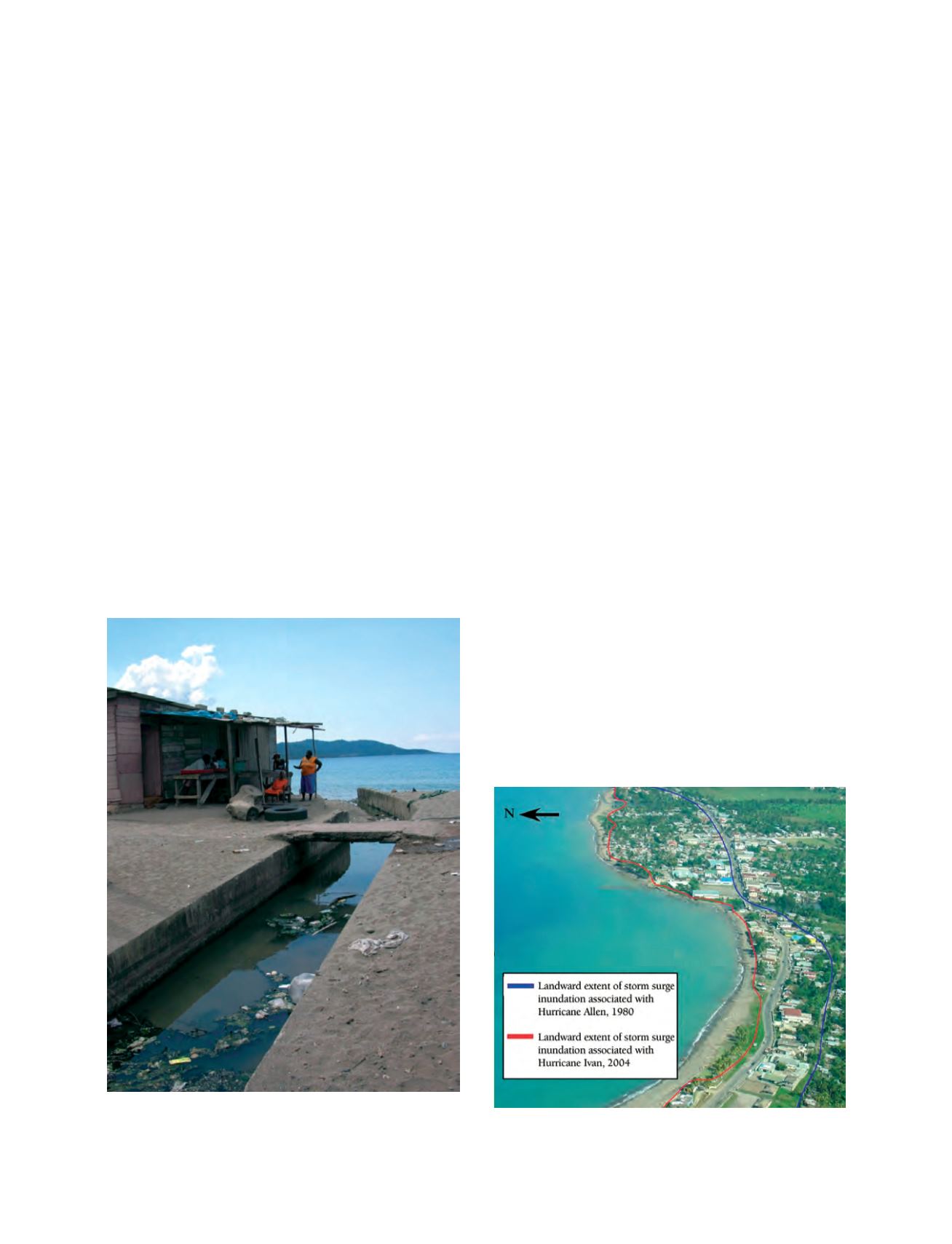
A study carried out by C. Wilmott-Simpson in 1980 assessed
the effects of storm surge in the area and produced a storm surge
inundation map for Hurricane Allen.
9
Anecdotal evidence has
also been compiled on the impact of Hurricane Gilbert in 1988,
Hurricane Ivan in 2004 and Hurricanes Dennis and Emily in
2005. No similar assessment or report for coastal erosion for
this area can be found, although the existence of six groynes
located throughout the bay, the remains of gabion baskets and
fragments of a broken sea wall which once acted as sea defences
indicate that coastal erosion has been acknowledged as a threat
to the community.
Risk perception at the local level determines the level of effec-
tiveness that a community-based mitigation programme will
have. Presently, riverine flooding is the greatest perceived threat
by the community, and is believed to be exacerbated by inade-
quate and frequently blocked drains. Although drain cleaning is
conducted periodically by the parish council, the frequency is
not sufficient to keep them clear. This, residents say, is the main
problem and needs a revolutionary approach. Through their
increased awareness of the causes of flooding, residents actively
participate in drain cleaning and removal of sand bars blocking
the mouths of Mother Ford and the Annotto River.
Storm surge and coastal erosion are acknowledged as a threat,
but impacts from storm surge are felt infrequently (Hurricane
Allen, 1980; Hurricane Gilbert, 1988; Hurricane Ivan, 2004).
Coastline retreat takes place over an even longer period of time,
and is not perceived by some in the community as a major
threat.
Through this project we have been able to identify the extent
of storm surge inundation generated by Hurricane Ivan and
compared it to that identified after Hurricane Allen to better
assess the impact storm surge has on the community. Analysis
of the offshore bathymetry in the bay was also undertaken to
determine whether this influences the impact of storm surge
along this section of the coastline. Evaluation of changes to the
coastline over the past 40 years was also carried out using aerial
photographs and seasonal variability of the beaches, identified
at five stations and monitored over an eight-month period. The
preparation of land use maps for the community was under-
taken to assess compatibility of present practices in the town
with the hazards that impact the area.
This project seeks to increase the understanding and aware-
ness of storm-induced hazards at the community level. A hazard
map, identifying areas which have been inundated in the past
and zones of coastline variability, was prepared through commu-
nity participation in meetings and surveys. The information may
be used as a tool in raising awareness though community group
education programmes. The availability of hazard maps of the
area as well as educational pamphlets describing coastal
hazards, will provide residents with information on the impact
that different hazards have on varying sections of the town and
will allow them to better prepare themselves in the future – to
be forewarned is to be forearmed.
A technical report will also be produce that will provide rele-
vant information for government agencies responsible for
developing mitigation strategies, for this and other coastlines
with similar characteristics. This may be used as a guide for the
future planning and design of developments along shorelines
with similar physical features.
[
] 64
Residents living on the banks of the Mother Ford. This drain is
frequently blocked by sand bars deposited by the sea, which residents
have to clear to prevent flooding of adjacent homes
Photo: Richard Coutou
Extent of storm surge inundation in the town of Annotto Bay from
Hurricanes Allen and Ivan
Photo: Nakula Butterfield