


 133 / 218

[
] 131
measurements, they also use normalized difference vegetation
index (NDVI) measurements to assess the impact of rain on
local vegetation. NDVI data derived from satellites measure
the photosynthetic activity resulting from vegetation growth
that occurs as a result of rainfall, and are an important source
of information for FEWS NET.
7
Because they measure very
different things, both variables continue to be of value to
hazard identification.
Members of the many FEWS NET organizations teleconfer-
ence weekly to discuss and identify potential flood and drought
hazards, and then prepare and issue weekly weather hazard
reports, which are posted on the FEWS NET site.
8
These reports
are delivered to a large local, regional, and international audi-
ence in Africa, Latin America, Asia, and in the United States.
They provide information that indicates where more intense,
on-the-ground monitoring should occur. The weekly weather
hazard discussions are led by the meteorologists at NOAA’s
Climate Prediction Center, and guided by FEWS NET food secu-
rity experts who orient hazard discussion towards identifying
its affect on local livelihoods.
By collaborating with scientists from NOAA, NASA and
USGS, as well as with FEWS regional and country represen-
tatives and the USGS FEWS NET regional representatives,
expert FEWS personnel work together to determine the
impact of these weather hazards on local communities. This
is done using a livelihoods-based analysis system that provides
the framework for interpretation of routine monitoring data,
for example rainfall, vegetation, crop production, and market
prices. These monitoring data are valuable indicators of food
security, but it is difficult to link changes in these indicators
to changes in the food security status of affected households.
9
Using remote sensing data constructively in a complex
environment
The FEWS NET activity is on its fifth reauthorisation at
USAID, and in the next phase FEWS NET will be charged
with continuing its current activities, expanding its
geographic scope, and increasing the types of issues it reports
on. This extraordinary length of experience coupled with the
diversity of its interagency and international partners make
the FEWS NET project worthy of study. Although FEWS NET
is unable to solve the underlying structural and fundamental
problems of the humanitarian and development sector, it
plays a key role in helping to prevent people from perishing
in crises, and ensuring that these crises are not ignored by
the wider world.
The need for FEWS NET reporting is projected to continue
to increase, and as it does it is crucial that the information
and presentation of its decision support analysis be as audi-
ence-focused as possible. In many regions, FEWS NET is
operating in a continually worsening environment, where
environmental hazards, increasing populations, and declining
investment in local data and information gathering, holding
and reporting activities result in increased reliance on outside
sources of information. Working in concert with multiple
governmental and non-governmental development agencies,
FEWS NET continues to play a key role in information gath-
ering and distribution for early warning of food insecurity in
the regions in which it works. The credibility of the infor-
mation it produces is one of FEWS NET’s primary assets in
its role of consensus building. Remote sensing information
and analysis remains at the centre of these efforts, as it is the
foundation upon which FEWS NET’s hazard identification
and food production analysis rests.
Examples of satellite contributions to
humanitarian action
There are numerous examples that demonstrate how data from
Earth-observing satellites have been used in data-sparse regions
of the Earth, improving estimates of food aid needs in vulner-
able areas. The following are some brief examples of the
existing products that have contributed to decision support.
Snow depth for water available for irrigation – The product
is used in estimating irrigated water supply and ultimately
food security for the northern regions of Afghanistan. Due to
an early melt of the snow pack in the spring of 2006, food
prices increased significantly in northern Afghanistan follow-
ing the harvest. Coupled with a shortage of animal food,
livestock prices have decreased by 30-40 per cent in the north-
western provinces. These factors together have increased food
insecurity, and the remote sensing data has provided a good
understanding of what was happening in an otherwise inac-
cessible region.
Extreme rainfall impacts on crop production in Honduras –
NASA data informs hazard analysis in Honduras, a country
that is very vulnerable to severe tropical weather. Basic grains,
African palm, banana trees, and sugar cane are particularly at
risk from damage caused by heavy rainfall throughout the
country. Immediate hazards to citizens from floods and land-
slides are also monitored. Heavy rains increase the risk of crop
plagues and disease (such as oidium) which can result in crop
losses between 25 and 30 per cent.
Crop production monitoring using MODIS data – MODIS
anomalies from a five-year mean are used to estimate crop
production anomalies and pasture deficits in semi-arid regions
of West Africa. The five-year mean from 16-31 October 2006
in West Africa indicated strongly positive conditions enabling
a recovery of food insecure regions of Niger.
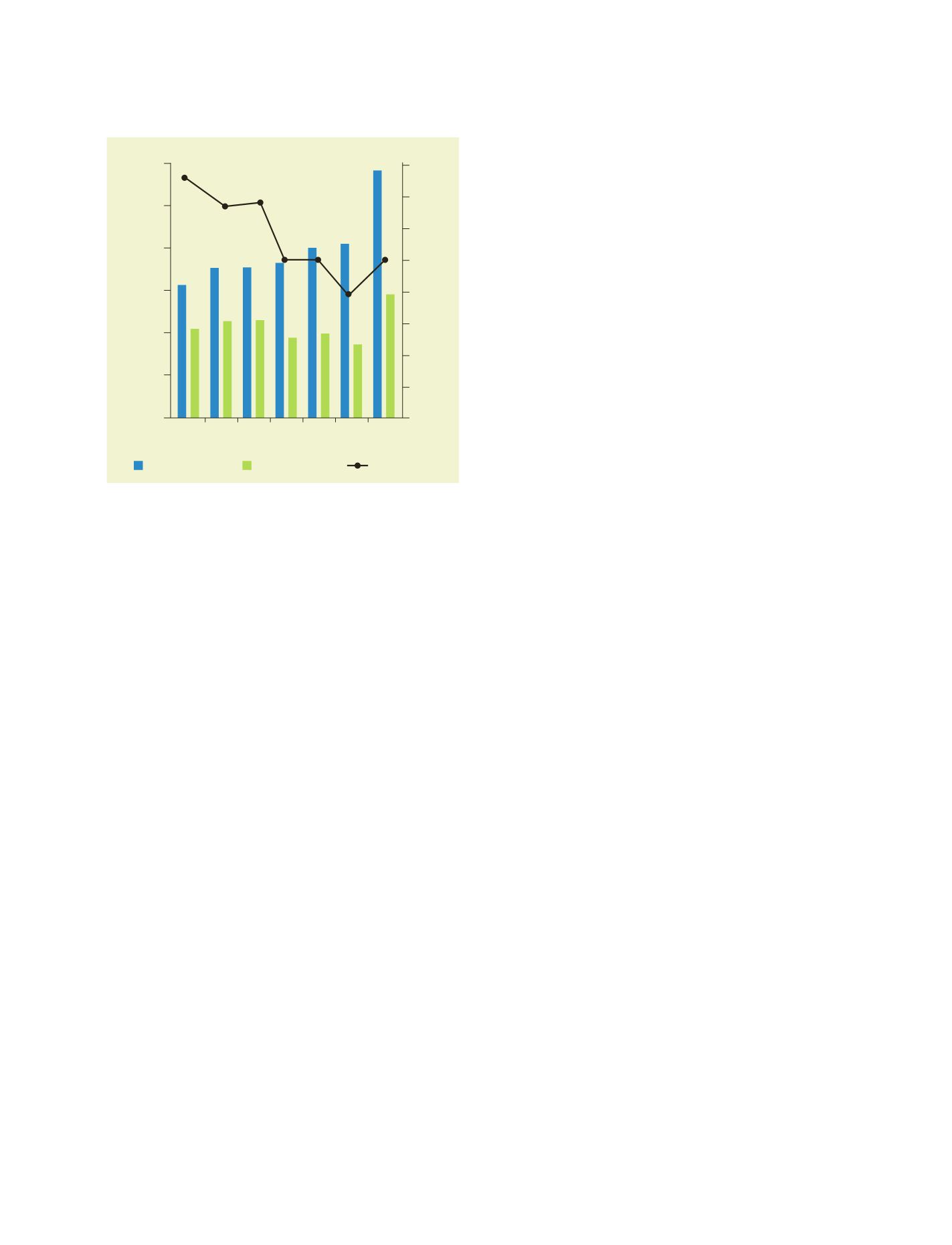
0
5000
10000
15000
20000
25000
30000
Year
CFAF
0
10
20
30
40
50
60
70
80
Kg Millet per Goat
Jan Feb Mar Apr
May Jun Jul
Millet price (100kg)
Goat price (1 goat)
Ratio Goat/Millet
Analysis of the terms of trade for pastoralists and farmers in Niger
seeking to sell livestock to augment food supplies
Source: NASA