


 153 / 218

[
] 151
The ICRIF agglomerates several factors, taking into account
both structural and meteorological indices, combining the FWI
with a fuel map and a vegetation parameter. It is calculated by
weighting the FWI value with a factor connected with a fuel
burn index, obtained from the CORINE 2000 (Coordination of
Information on the Environment), and a vegetation index, the
NDVI. The weights are values scaled from 0 to 100 and the
final value of ICRIF can range from 0 to about 100.
The CORINE 2000 database is an update of the old CORINE
1990, a programme introduced by the European Commission
in 1985, in order to gather information relating to the envi-
ronment for the European countries. CORINE land cover is a
European wide land cover and land use classification, produced
using satellite images. The mapping accuracy is at least
100metres.
Forests are periodically burned, resulting in an immediate
change of the land cover in the burned surface. This can result
in the recovery of natural vegetation or forest species that were
present before the fire affecting the structural fire risk map.
The new characterization of the land cover is completed,
updating the value of the fuel risk pixel. This update is done
at least once a year at the beginning of the fire season (April)
and can be done using imagery and observing changes in the
NDVI index.
The Normalized Difference Vegetation Index (NDVI) is one
of the most used vegetation indexes and is a measure of the
amount and vigour of vegetation at the surface. The magni-
tude of NDVI is related to the level of photosynthetic activity
in the observed vegetation. NDVI is calculated using measure-
ments from the Advanced Very High Resolution Radiometer
(AVHRR) on board the USA’s NOAA polar orbiting meteoro-
logical satellites. The reflectance measured from Channel 1
(visible: 0.58 - 0.68 microns) and Channel 2 (near infrared:
0.725 - 1.0 microns) is used to calculate this index. The differ-
ential reflectance in these bands provides a means of
monitoring density and vigour of green vegetation growth
using the spectral reflectivity of solar radiation. Green leaves
commonly have larger reflectance in the near infrared than in
the visible range. As the leaves come under water stress,
become diseased or die back, they become more yellow and
reflect significantly less in the near infrared range.
Clouds, water and snow have larger reflectance in the visible
than in the near infrared, leading to a negative value of NDVI,
while the difference is almost zero for rock and bare soil. The
NDVI is affected by a number of different phenomena, includ-
ing cloud contamination, atmospheric perturbations, variable
illumination and viewing geometry, all with an impact of reduc-
ing the NDVI value. To address these effects, NDVI data is often
used as a composite, taking the maximum value over a speci-
fied time period, usually a week or ten days. To minimize the
error due to illumination and viewing geometry, every day a
program chooses the image NOAA with the best observational
zenith angle below 45 degrees and the best solar zenith angle
below 35 degrees of the solar elevation angle. With this image
a geometric correction is automatically made by the receiving
station with several reference ground control points. The final
error is estimated on a one-pixel basis.
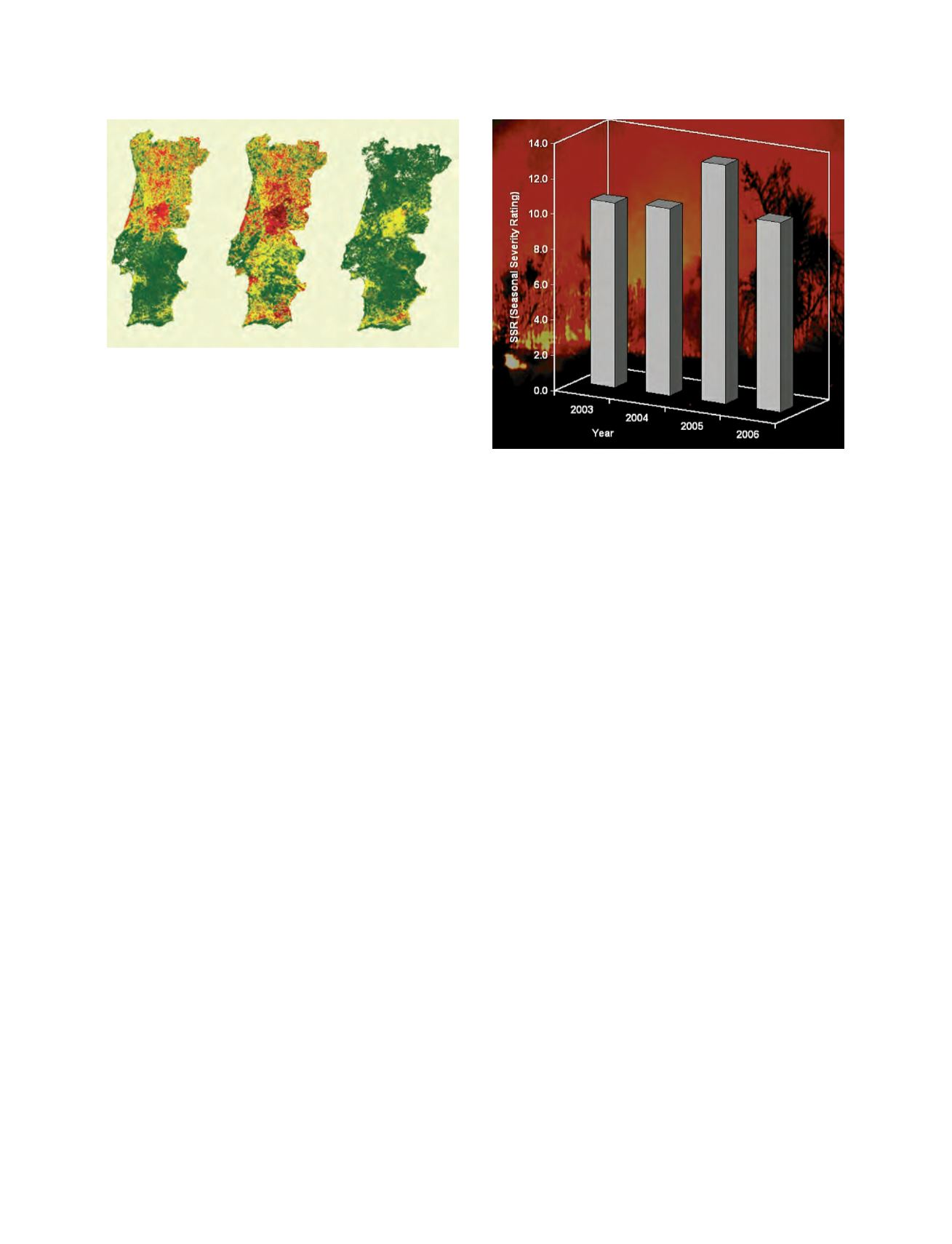
An example of the ICRIF is shown here, which illustrates
that by the end of May and beginning of June there were very
good synoptic conditions for forest fires in the northern part
of Portugal. On the contrary, in the southern part of Portugal,
the lower temperature and cloudy conditions were observed
with precipitation in some of the regions.
The third image illustrates the severity of the fire risk regis-
tered in Portugal during the fire season over the past years.
You can see that the severity rating has been generally very
high, but in the year 2005 it reaches an exceptional value.
Although in 2006 the fire risk was also very high on some days,
they were interspersed with periods of precipitation, impact-
ing the overall risk assessment for the year.
Both FWI and ICRIF are used by the civil protection agency
to prevent and combat forest fires. From this information
several measures can be taken to protect the areas where the
risk is higher.
During the summer of 2006, the value of the fire risk was
recognised as very useful information, reducing the impact of
forest fires, and therefore reducing the number of occurrences
and burn area. This daily contribution to support forest fire
prevention and combat is an example of successful coopera-
tion between decision makers, in this case the Portuguese Civil
Protection Service and the Portuguese Institute of
Meteorology.
Source: IM Portugal
ICRIF values showing the evolution of the fire risk
Source: IM Portugal
The evaluation of seasonal severity of fire risk in Portugal