


 126 / 168

[
] 126
Development (ICIMOD), the Centre for Remote Imaging, Sensing
and Processing (CRISP) of National University of Singapore,
the Central Asian Institute of Applied Geosciences (CAIAG) of
Kyrgyz, China Earthquake Administration, the National Institute
of Aeronautics and Space (LAPAN) of Indonesia, Ministry of
Natural Resources and Environment (MONRE) of Vietnam, the
National Center of Space Researches and Technologies (NCSRT)
of Kazakhstan, the Survey Department of Sri Lanka, Ministry of
Disaster Management of Sri Lanka, Agency for the Assessment
and Application of Technology (BPPT) of Indonesia, and Manila
Observatory of the Philippines have joined the framework. In case
of emergency observation, the DAN members analyse the satel-
lite data (raw data in principle) provided by the DPN together
with their own data, such as local maps, and make value-added
products.
The following steps will need to be followed to make the best use
of data:
• Cooperation for disaster risk reduction in the preparedness
phase in addition to post-disaster phase activities
• Regional cooperation including end-users
• Human resources development and human network.
Expansion of activities into disaster risk reduction
In addition to disaster management in the response phase, mitiga-
tion and preparedness activities are planned. Hazard maps, a fire
danger rating system (FDRS) for wildfire alert, and an early warning
system for GLOF are being studied.
Regional cooperation
For the purpose of utilizing information provided by Sentinel Asia,
regional cooperation focusing on specific countries/areas is essential.
For example, in the case of wildfire management, a JICA/JST project
has been initiated for wildfire and carbon management in peatland
in Kalimantan, Indonesia.
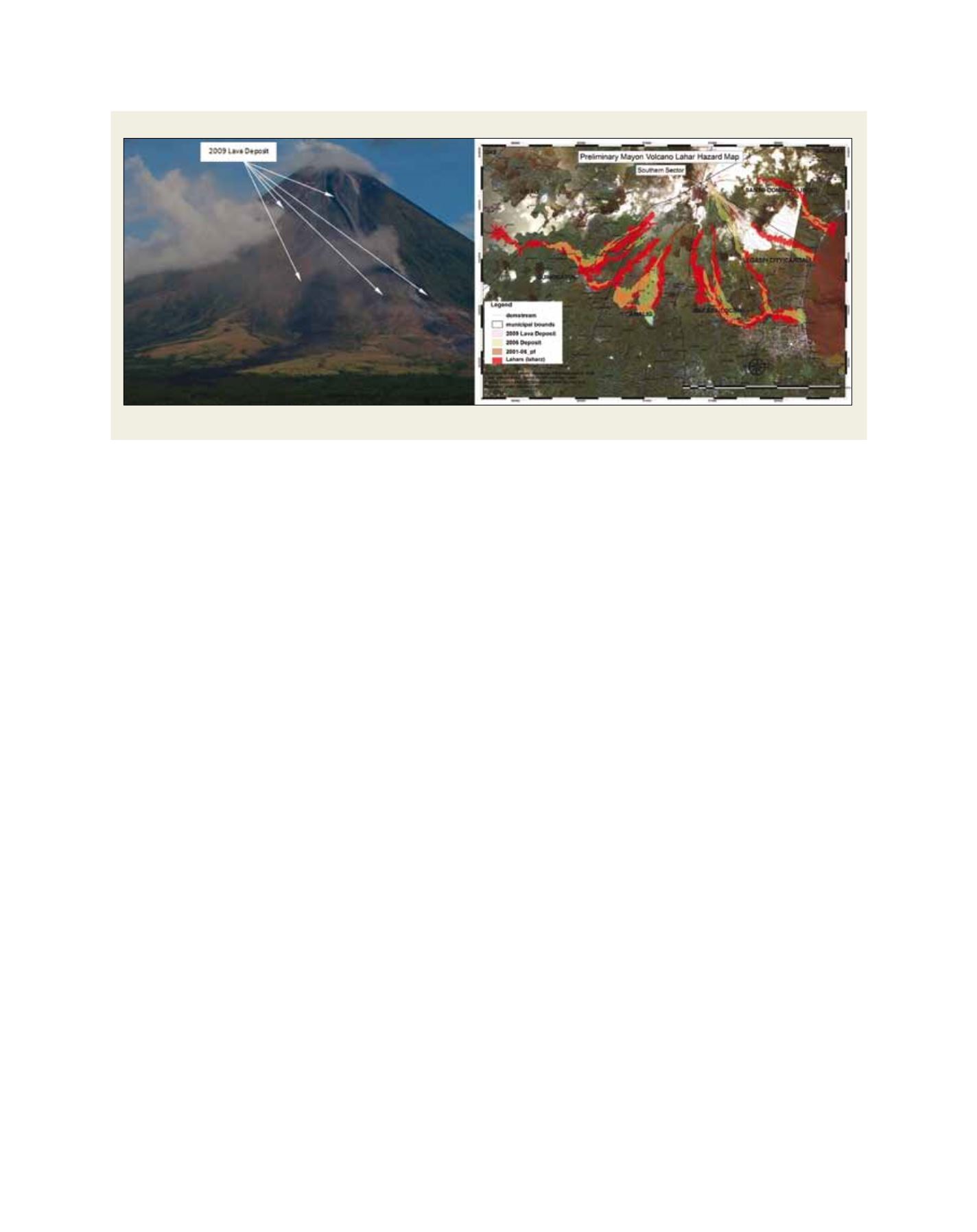
We have already started an activity, Sentinel Asia Success Story
(SASS) – a cooperation with the Philippines to create hazard maps
using ALOS data. During the eruption of the Mayon Volcano in
December 2009, this SASS framework worked very well.
The lahar hazard map, prepared beforehand by SASS,
was updated by the Philippine Institute of Volcanology
and Seismology (PHIVOLCS) using ALOS imagery
observed after the eruption, and the updated hazard
map was used for an evacuation alarm to residents.
Working together with other initiatives
Collaboration for emergency observation in the
Asia-Pacific region between SA and the International
Charter for Space and Major Disasters (IC) was
agreed at the JPT meeting held in Bali, Indonesia in
July 2009. In the event of an activation of SA emer-
gency observation, SA can also activate the IC in
order to increase the satellite resources to observe
disaster-affected areas.
Human networks
For the purpose of building and strengthening human
networks, SA system operation training is to be held
by JAXA once or twice a year in cooperation with AIT,
ADRC, ISRO, GISTDA, NARL and others.
Sentinel Asia has been developed steadily since
operations began in October 2006. Based on the valu-
able lessons learned in Step 1, SA has moved to Step
2, enhancing and strengthening its activities. A good
human network is the foundation of the project.
Wildfires and floods are global issues that call for
a cooperative approach by the international commu-
nity. SA is a dedicated initiative for the Asia-Pacific
region, but its concept can be extended to a new idea
of Sentinel Earth – a kind of ‘Aufhebung’ from existing
initiatives. Using current space-based disaster manage-
ment initiatives, Sentinel Earth has the potential not
only to cooperate and create synergy among existing
initiatives, but also to initiate new activities for areas
not covered by them.
Example of Disaster Risk Reduction
Eruption of the Mayon Volcano in the Philippines in December 2009 and lahar hazard map used for an evacuation alarm to alert residents
Source: PHIVOLCS