


 145 / 196

[
] 143
(population distribution and density, income, asset
values etc). All this information can be allocated to a
geographical distribution, and is therefore applicable to
a GIS.
When supporting early recovery and development
activities carried out locally by actors in dire need of
geographic information on the territories of which they
are in charge, one realizes that data and information
generated at the time of previous crises and disasters is
an information resource yielding excellent returns if
properly stored and accessed.
UNOSAT works by offering crisis response mapping
to users (UN and non-UN, international as well as
national), at no cost. These products are enriched later
with additional information, or layers, to be used in
support of recovery and development measures on the
ground. Although the user requirements are multiple
and sometimes cannot be met with the same type of
map, we maintain constant efforts to ensure that users
in the field can also access these products at no cost.
Our participation in the Global Monitoring for
Environment and Security (GMES) project ‘Respond’,
for example, has enabled several users to enjoy free dedi-
cated mapping. In addition, their feedback is factored
into the overall GMES process so that user needs are
part of the design and planning activity of the entire
GMES programme.
In supporting a growing number of national and inter-
national development projects, we have grown deeply
aware of the central role of remotely sensed information
in strategic territorial planning and advanced GIS appli-
objectives.
1
This includes the use of integrated solutions. The
UNOSAT approach is innovative in that it suggests a new paradigm,
combining technical soundness with a constant focus on users and
their needs. The result is a number of activities and methodologies
aiming to produce concrete solutions with high impact at low cost.
Structural as well as technical running costs are still an issue in
the world of space applications, but their relative weight is constantly
decreasing. UNOSAT’s experience since 2001 has taught us lessons
which we have submitted to the attention of both donors and users,
with positive outcomes. Here we would like to share some of these
experiences, followed by some issues that are raised by them.
The study of the applicability of satellite solutions to risk and
vulnerability begins with the post or pre-disaster phase, depending
on the point of view of the observer. Satellite applications best
express their intrinsic potential when addressing disaster preven-
tion, (defined as the assessment and reduction of vulnerability to
manage a certain risk until its impact may be considered preempted).
Satellite remote sensing offers the best bird’s eye view of hazards and
vulnerability levels because it couples objectivity with the possibil-
ity of repeating observation over time.
From the macro-level to the micro-level, all solutions seem to be
within reach now that very high resolution is available from commer-
cial satellites. Yet imagery alone is not enough to ensure disaster
prevention: the importance of local knowledge and indigenous prac-
tices is paramount. Satellite maps have shown incredible value as
background geographic information on top of which multiple data-
bases can be overlaid.
Local risk analyses are carried out by combining geophysical and
geographical parameters, (such as satellite-derived analysis, land-
cover type, elevation, slope, hydrographic network, administrative
units and place names), with security or socioeconomic parameters,
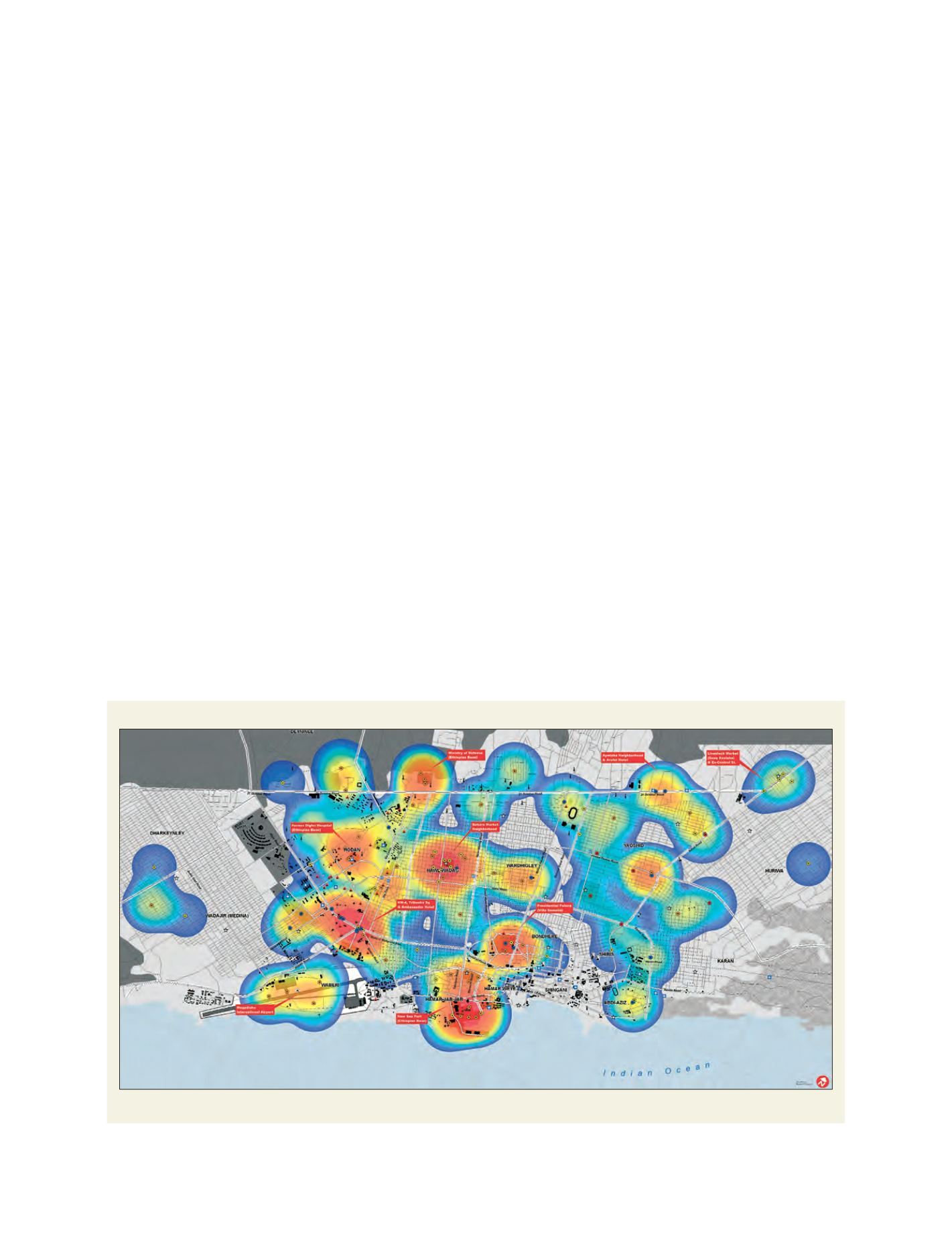
Security incidents in Mogadishu
Reported security events in Mogadishu, Somalia: 29 December 2006 to 3 March 2007
Source: UNOSAT