


 96 / 280

[
] 96
water and tourism. Developing the data collection
network is a central objective of the PI-GCOS
programme and a cornerstone of enhancing capacity for
weather and climate observations in the Pacific
Islands region.
Pacific Islands Global Ocean Observing System
Initiated in 1998, PI-GOOS is a regional alliance hosted
by the Secretariat of the Pacific Islands Applied
Geoscience Commission (SOPAC) from its offices in
Suva, Fiji. As a global programme, GOOS aims to
develop a permanent system of observations, modelling
and analysis of coastal and ocean variables. Within this
broad scope, regional alliances provide an effective
mechanism for tailoring the GOOS programme to meet
the specific needs of diverse communities around
the world.
Given the scale and importance of the Pacific Ocean
and the small size of many of the island nations scat-
tered across the region, the drivers and needs for coastal
and ocean observations are understandably quite differ-
ent from those of other regions, such as Europe and
Africa. One of the major differences is in the way in
which ocean observations are collected. The Pacific
Ocean is a major driving force for global climate process
and therefore has received considerable attention from
oceanographers and marine meteorologists for
many years.
The number of observation and monitoring platforms
that have been deployed in the Pacific is vast and
growing, particularly through initiatives such as Argo
(www.argo.net), a programme designed to increase
global coverage of temperature and salinity measure-
ments via systematic deployment of 3,000 profiling
floats. Programmes such as Argo and ones similar are in
all cases implemented by nations bordering the Pacific
and farther afield. Involvement from Pacific Island
nations in whose waters the observations are being
collected is invariably limited to providing official
permission for instruments to be deployed within
their EEZ.
The PI-GOOS programme therefore aims to bridge the
divide between data collectors and Pacific Island nations
in two ways. First, by helping to build national obser-
vational capacity where needed, such as for mariculture
Pacific Islands Global Climate Observing System
Established in 2000 at a regional GCOS workshop in Samoa, the
creation of PI-GCOS reflects the recognition by Pacific Island coun-
tries that long-term, high quality observations of the region’s climate
are essential for improving forecasting capability and our under-
standing of both regional and global climate change. PI-GCOS is
hosted by the Secretariat of the Pacific Regional Environmental
Programme (SPREP) from its offices in Apia, Samoa. The primary
objective of PI-GCOS is to improve the quantity and quality of
climate and weather observations for the Pacific Islands region. This
is achieved by assisting National Meteorological Services (NMS) to
develop and strengthen the capacity of their observational networks.
The data generated from enhanced observation platforms can then
be used to develop improved and accurate climate and weather infor-
mation, services and products to local communities.
Climate observations collected in the region include: long-term
routine weather observations; specialized and general research obser-
vations; and proxy environmental climate data, designed to extend
climatology time series in more remote regions to periods before
weather instruments were available. In order to build the observa-
tional networks to collect these diverse data, capacity building efforts
are directed at the following key areas: short- to long-term climate
forecasting capability; communication links; training of climate
personnel; and developing climate information services with stake-
holders in key government and private sectors such as agriculture,
Installation of tipping-bucket rain gauge on Funafuti, Tuvalu
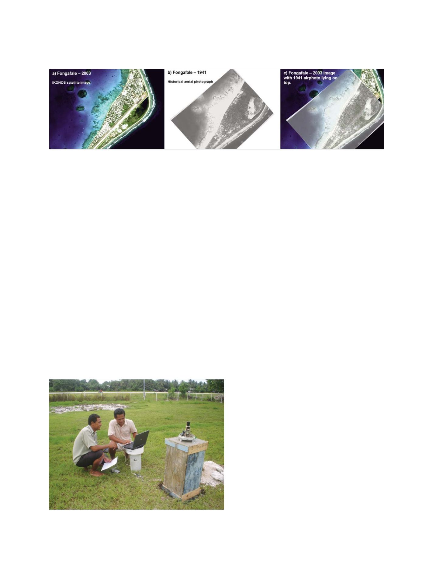
Georectified contemporary and historical imagery for Fongafale islet, Tuvalu
Source: Webb, A. P. (2006)
Photo: SPREP
GEOSS C
OMPONENTS
– O
BSERVING
S
YSTEMS