


 88 / 208

[
] 88
E
nvironment
:
air
,
water
,
oceans
,
climate
change
previous year’s rainfall or to the amounts of water
stored in the upstream country in previous years. In
practice, the flow continuum is taken into account in
areas where man-made changes to the natural river
regimes are substantial.
On top of these verifications there is a strong inter-
change of information coming from 13 rain gauges, 10
flow gauges and six reservoirs (with joint capacity of
7.25 km
3
, that is, billions of cubic metres), mentioned
in the text of the Convention and implemented de facto
in the management routines of each country’s water
services.
This exchange of information is of vital importance
in the verification of the Convention, especially for dry
conditions. During the management of other extreme
hydrological conditions, such as floods, the amount of
information exchanged is substantially enlarged, due
not only to hourly interchange timespans but also to
the increasing number of rain gauges, flow gauges
and reservoir inflows and outflows considered. All
the information is made available through web server
protocols.
In the management of floods in the Tagus river basin,
cooperation is more developed than in other areas for
historical reasons. Not only is there an exchange of
data relevant for each country’s flood management
(flow data for the downstream country and rainfall
data for the upstream country, since storm paths move
inland from the ocean) but also, importantly, there is
an exchange of the reservoir management strategy for
a period of time. Due to this capability of cooperation,
it is possible to lag and route flood components in
such a way that peak flows are significantly attenuated,
either by avoiding overlapping of flood components
from tributaries or by adjusting downstream flow
releases from reservoirs.
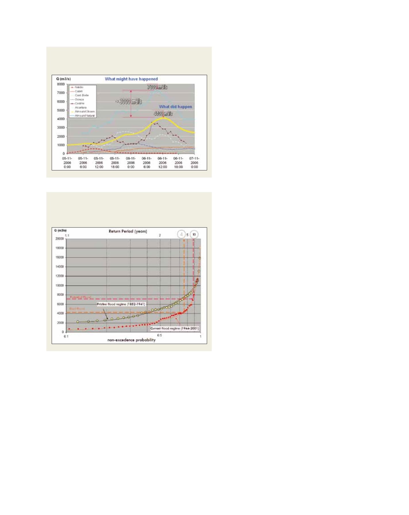
Figure 2 shows how a potential peak flow of 7300
m
3
/s (light blue graph component) was attenuated to
4100 m
3
/s (yellow graph component), reducing by
more than 3000 m
3
/s its severity.
Through this cooperation a ten-year return period
flood was shortened to a four-year return period flood,
carrying less damage downstream to the Tagus flood-
plain.
These examples of management cooperation during
extreme weather conditions have become quite common
since 1995. The good cooperative relationship built up
around technical aspects was eventually transmitted
to the political level and the partnership, which began
informally in the technical field, was identified as an
example of good practice and incorporated in the text
of the Convention. A process that started with technical
harmonization concerns as its driving force reached its
conclusion in the political field with the achievement
of a ‘goodwill’ text, leaving the fine-tuning of some
technical details for further development during the
implementation phase. The Water Framework Directive
text was also an inspiring source during the discussion
of the bilateral Convention.
For each of the four major river basins shared between Portugal
and Spain, minimum assured flows were defined, at annual and
three-month period scales, and for two of them, the flow regime
was downscaled on a weekly basis.
All these minimum flows (annual, seasonal and weekly) might
not be maintained in very dry years and exemption procedures
were built for each river basin in order to define its applicability.
In general terms, this is an accounting procedure based on rainfall
in five- to eight-month periods within each hydrological year and
its degree of compliance with minimum thresholds defined on
certain percentages of the mean values. Since the torrential char-
acter of the flow regimes increases towards the southern basins,
the exemption verifications in these situations are anticipated in
time and become more complex, adding thresholds also to the
Source: National System of Information Resources
Source: National System of Information Resources
Figure 2: Peak flood attenuation of 3000 m
3
/s occurred in
November 2006 in the Tagus river basin due to the cooperation
between upstream (Spain) and downstream (Portugal) countries
Figure 3: Statistical plot of flood regimes (pristine regime prior to
upstream dam construction, and man-made altered since 1940s)
and severity change in the November 2006 flood in terms of
return period